
West Berkeley Air Monitoring
Part 1
West Berkeley Air Monitoring Part 1 or continue to: West Berkeley Air Monitoring Part 2
Eric D. Winegar, Ph.D., Q.E.P. Applied Measurement Science
September 6, 2000Introduction
The City of Berkeley Planning and Development Department contracted with Applied Measurement Science to conduct a survey sampling program intended to provide information on pollutant concentrations throughout the city. This limited program was intended as a first phase in a potential larger program that would provide in-depth information on pollutant exposures to residents of the West Berkeley area. This program was intended as a screening survey for a wide array of pollutants that may impact residents of West Berkeley and surrounding areas.
The program was designed to answer the following questions:
- What pollutants are the residents of West Berkeley exposed to?
- Are any of these pollutants of particular concern?
- What is the impact of the 1-80 corridor?
- What is the impact of the industrial sources in the area?
- Determine if possible, what compounds were causing odor complaints in the West Berkeley area.
- Is the West Berkeley area significantly different from other areas of Berkeley?
- What should be done for further monitoring?
This report presents the results of the monitoring program and provides answers to these questions. It should be noted that it is beyond the scope of this program and this report to provide any quantitative human risk assessment. A risk assessment would require a significant additional effort both in data collection and data analysis.
Measurement Targets
A total of 184 standard analytes plus up to 20 additional tentatively identified analytes were examined over each of the-sampling days:
- Total Suspended Particulate (TSP)-total dust of all sizes in the atmosphere produced by both natural and anthropogenic sources.
- Particulate matter less than 10 microns aerodynamic diameter (PM10) - one analyte. PM10 is produced by both natural and anthropogenic activities. PM10 is a national and state criteria pollutant and has been associated with health impacts due to inhalation.
- Particulate matter less than 2.5 microns aerodynamic diameter (PM2.5) - one analyte. Also called "fine" particulate, PM2.5 is associated with stronger health impacts due to its capability to be inhaled more deeply into the lungs. US EPA has proposed PM2.5 as a criteria pollutant in the future.
- Black carbon - one analyte. Black carbon was chosen as a surrogate for diesel exhaust.
- Total Polycyclic Aromatic Hydrocarbons (PAH) - one analyte. PAH compounds are formed primarily from combustion proceses, particularly diesel engines.
- Hydrogen sulfide - one analyte. Hydrogen sulfide is both a natural product of anaerobic decomposition and a product of anthropogenic activities such as combustion and other industrial processes.
- Volatile organic compounds (VOCs) - 62 standard analyte, plus up to 10 tentatively identified analytes
- BTEX (benzene, toluene, ethyl benzene, and xylenes (m,p-,o-) - 5 analytes. As a subset of VOCs, BTEX is produced primarily as a byproduct of automotive and diesel combustion engines, although small amounts are associated with evaporative emissions of fuel from cars and trucks.
- Aldehydes and Ketones - 12 analytes. This class of compounds is a subset of the volatile organic compound category and originates both as industrial solvents and as byproducts of combustion or other industrial processes.
- Semi-volatile organic compounds (SVOCs) - 64 analytes, plus up to 10 tentatively identified analytes. SVOCs are produced in various processes, primarily combustion and other high-temperature industrial processes.
- Metals - 36 analytes. Metals in various states of chemical composition are the primary constituent of most aerosols.
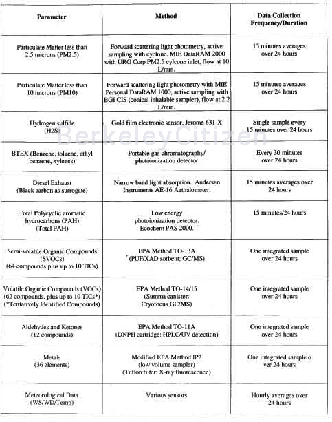
Several of these parameters were collected using continuous measurement instrumentation, and others were collected using standard integrated air sampling methods. Table 1 lists the methods used and the time domains for each.
Table 1. Sampling and Analysis Methods
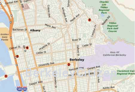
Sampling Locations
The sampling locations were selected based on several considerations. First was the general location to provide a neighborhood scale representativeness of the sampling. The second consideration was the absence of specific localized emission sources that would skew the data. Finally, logistical and security considerations were considered. These last considerations were necessarily a major part of the siting plan due to concerns about equipment security and the necessary access to 120 VAC line power.
The final selected locations did not fit all the formal guidance related to sampling location guidance, but were compromises based on the above considerations. For example, trees were within 30 feet in all the locations except for Dicon. At Dicon, the parking lot included perforce the possible inclusion of extra automotive emissions. The Goodyear site was adjacent to automotive work, which may have influenced some solvent related emissions.
These compromises were recognized at the outset and were accepted due to the nature of the study, the requirements of the equipment trailer, and the need for data in certain locations. An informal review of data collection during the data collection period and a review of the total data sets after completion suggest that these compromises did not materially affect the integrity of the data collection effort, and that the overall objectives were still met.
As a survey program, a cross section of sampling locations was chosen in order to determine if any one area of the city were to show significantly different species concentration profiles than any other. Five locations were selected as listed below based on the cited considerations:
1. Background A background location was needed to determine possible upwind and/or background contributions. The Berkeley Marina was chosen as the background due to its location upwind of 1-80 and the main Berkeley urban area. The sampling site was a small lot adjacent to the playground on the south side of the Marina. This location was directly facing the predominant winds from the west to southwest, and as such would include regional contributions from San Francisco and southward toward Silicon Valley. No other localized upwind sources were nearby.
2. Adjacent to the busy 1-80 corridor. As an obvious possible source of vehicular emissions, two days of testing along the 1-80 corridor were selected. One day each of weekday and weekend day were selected in order to determine the possible difference between the workday commutes and the non-workday traffic patterns. A location along the frontage road in the parking lot of Kaiser Permanente manufacturing facility (1725 Eastshore Hwy ) was selected based on its proximity to the highway, the availability of power, and the site security (24-hour gate access). Other locations along that corridor had been investigated, but could not be confirmed due to various factors, primarily access and permission. The Kaiser site does use minor amounts of volatile organic compounds, but the sampling location was upwind of those locations, and the dominant wind coming directly off the bay and across 1-80 would ensure that any small emissions would not affect the sampling location.
3. Downwind of the industrial areas along 1-80 and West Berkeley. The sampling location directly downwind of industrial areas was found at the parking lot across from 1331 Eighth Street, which serves Dicon Fiberoptics, Inc. The parking lot did have the potential for some short-term effects to the emissions profile, but after watching the traffic pattern, it appears that the pattern was random-there was only a minor influx in the morning, and then exits were at various times. Therefore, it is believed that the parking lot location did not substantially affect the data set. The lot is several blocks downwind of local industrial facilities, and as noted below in the Results section, odor was noted during the sampling period and workers have detected odors periodically.
4. Downtown A downtown location was selected in order to examine the concentration and chemical profile for a high traffic and high population density area. The parking lot of Goodyear Tires on the corner of Martin Luther King and Addison Streets was chosen for this site. Potential localized emission points include the tire store itself and local traffic. The tire store primarily services tire products and does not do general automotive repair
5. The Berkeley hills A location high in the Berkeley hills was selected in order to test the assertion that the regional emissions from the coastal plain were diluted or dispersed by the dominant wind coming through the Golden Gate passage. A residence at 1097 Creston Road was used for this location.
Map of Berkeley Air Monitoring LocationsField Events
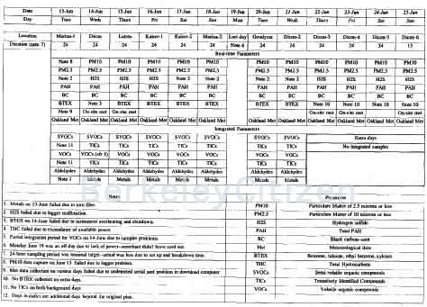
Sampling was conducted starting on midnight, Tuesday, June 13 and continued through mid-day, Sunday, June 25. Daily sampling comprised nominally midnight to midnight, although set up, break down, and moving the equipment cut this time by 1-2 hours each day. These periods were reflected in the final data tables.
Notable Events
A primary notable event during the sampling period was the announcement of a "Clear the Air Day" by the BAAQMD. This occurs when conditions suggest high impacts from pollution, particularly stagnant wind conditions. This occurred on Wednesday, June 14, but the trend began to be seen the previous day. The meteorological conditions for that day were typical of a high pollution day-calm winds and high temperatures. The data confirms these effects, with the highest concentrations measured on that day.
On Monday, June 19, the sampling had to be discontinued for one day due to the lack of a power cord at the Goodyear parking lot at Martin Luther King Boulevard and XX Street. The manager had been reminded of the need to leave an extension cord out on Saturday afternoon, but evidently, one of the employees who wasn't aware of the plan removed it at closing time. When set up was attempted on Sunday midnight, no power was available. Therefore, that day was not lost, but just pushed to the next day, Tuesday.
No other significant event occurred to affect the data.
Equipment Problems and Failures
For the most part, the equipment functioned well. However, there were some significant problems that prevented the complete utilization of the equipment and that changed the data collection scheme somewhat.
1. Total Hydrocarbon Analyzer. The total hydrocarbon analyzer (continuous direct flame ionization detector-FID) could not be used due to the power that was needed to operate it. The incremental increase in power required by this system caused overdraws of the power for the other equipment and caused circuit breakers to switch everything off. In particular, the high volume PUF sampler draws several amps continuously, and with the other equipment the draw was too much for the power being drawn through the long extension cord.
Therefore, after several tries, this system was abandoned. 2. Meteorological Sensors. Several days of on-site meteorological data were lost due to an undetected serial port problem with the download laptop. Periodic checks were made to ensure that the met sensors were sending data to the laptop, but the hourly download did not produce any error messages that the serial port was acting erratically. Therefore, a majority of the on-site meteorological data was lost. However, data from the Oakland airport was used to fill in these gaps, and these data are still representative of the entire region due to the general pattern of wind speed and direction influenced by the Bay. Consequently, there was no major loss of information from this failure.3. Filter torn. The metals sampling filter for the first day of Marina testing tore after several hours and since the exact time was not known, the sample failed and no information could be gathered.
4. Canister samplers. The sample pump for the canisters on the first day of Marina sampling and the first day of testing at Dicon was acting erratically, so the sample integration for those two days is uneven. The data appeared only marginally affected by this problem. Another type of canister flow controller was used in subsequent days to eliminate this problem.
5. Portable GC. After data collection was complete, it was determined that the portable GC required more constant surveillance that was possible due to the scheme of using automatic data collection in a trailer.
In addition, several parts of various days were lost due to clear signs of equipment problems. For example, on June 14, due to the high outside temperature (greater than 100°F) the internal temperature of the trailer exceeded the operating limits of the instrument and it shut off. This circumstance also occurred at other times, although the frequency was lessened by closer surveillance. Power drops also caused a few outages. In terms of data quality, a number of problems caused a decrease in the value of the data. First, the heat on a number of days caused erratic performance of the detector electronics.Second, a high number of low concentration organic species for which the unit was not calibrated caused a higher baseline in general. Each species is lower than the formal detection limit but is still present at high enough concentrations to register a small peak on the chromatogram. This circumstance is common in urban areas. The consequence of this increased baseline is a much higher detection limit for the BTEX compounds. Although there were several detections of these target compounds, the raised baseline was the cause for many false positives, and overall made for difficult integration of the peaks and doubtful quantitation.
Furthermore, the relatively unsophisticated data reduction software proved inadequate for this circumstance and could not provide adequate data quality. The effect of these circumstances were detected only after the data collection was complete and the entire data set could be examined, and therefore no corrective action could be applied. The conclusion of the data review for the portable GC is that it turned out to be of little value. This performance confirms the value of this particular GC for situations with typically higher concentrations such as fence line monitoring at remediation sites.
As noted above, some problems were detected immediately in the field, while others were discovered during the final data assessment. For the immediately detected problems, in order to compensate for equipment failure, etc., additional samples were collected and additional days of automatic data collection were appended to the original list. The original plan included six days of monitoring. With the additions, the total number of days was 10 and a half days, with 8 days of integrated samples instead of the original 6 days of integrated samples.
Laboratory Events
The laboratory analysis proceeded normally, without any particular problems.
Data Capture
The data capture for the entire program was satisfactory, including the equipment problems noted above. Table 2 contains a list of the data capture details, and includes notes on various minor aspects of the sample collection efforts. As noted above, due to problems with some equipment, additional samples and monitoring days were appended to the program, and these additions are included in the table.
Table 2. Data Capture
Results and Discussion
The data collection included both time-integrated and real-time continuous monitoring. In order to understand any differences between days and locations, mostly daily averages will be presented except for any other notable events represented in the real-time data. In addition, due to the large number of tables or graphs of the real-time data, in the interest of readability, the full real-time graphics will be included in the appendix. However, any notable feature will be presented and discussed as appropriate. In general, the real-time particulate matter monitoring did not show as much time-resolved structure as the diesel or PAH monitoring, which showed the expected trend of higher levels during commute periods, etc, reflecting the vehicular sources. More details will be presented in this section on each set of monitoring data.
It should be noted that the small number of samples collected can provide only a snapshot of the environment sampled. In order to more effectively gauge exposure over various atmospheric conditions, a larger number of samples over a longer period should be collected. For example, as noted above, the stagnant conditions on June 14 were atypical and although high concentrations were captured, it is clearly due to these particular conditions, which were not typical of usual West Berkeley weather patterns. Therefore, only a limited amount of information can be drawn from these data sets in regard to long term trends.
Note that in the following tables, blank cells indicate a non-detect (ND) for that sample and chemical parameter.
Particulate Matter
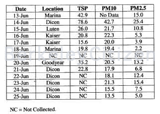
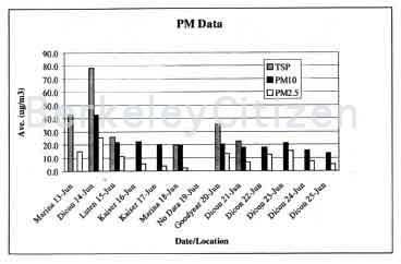
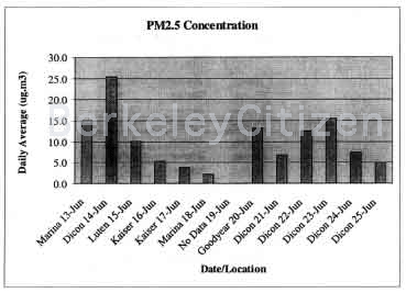
The total suspended particulate data was obtained from the gravimetric determination of weight gain from the filters sampled for metals. This sample collection was integrated over the nominal 24-hours-the final results represent the daily average. For PMI0, the daily average was obtained from averaging the daily data from the PDR light scattering photometer, and the PM2.5 daily average was obtained from averaging the daily data from the DataRAM. Table 3 contains a summary of the data. Figure 6 shows a comparison of the sites and the three main particulate parameters. Two data points are not included from the Kaiser location on Jun 16 and 17 due to their being lower than the PM10 data, which is not internally consistent and suggests a potential problem with those data points.
Table 3. Particulate Matter Summary (Daily Averages in ug/m3)
The major notable implication of these data is that no state or federal air quality standards (50 ug/m3 for 24 hours for PM 10, 65 ug/m3 for PM2.5 over 24 hours) were exceeded during this period, including the heavily polluted day of June 14. The measured values reveal various information about the various sampling locations. First, as was seen in all the other parameters measured, the June 14 concentrations at Dicon were significantly higher than any other day. In addition, the June 13 data from the Marina suggests that the conditions for the poor air quality on June 14 were already starting to build. In fact, the real-time PMl0 data for June 13 at the Marina show an increasing concentration over the entire day, suggesting a formation of the conditions necessary for the stagnant and hot air masses that were notable on June 14 at Dicon.
The other PM values are generally consistent with the expected contributions due to location and nearby sources such as traffic. However, the overall concentrations of PM10 did not vary significantly compared to other parameters. For example, while the Luten site showed lower concentrations of many pollutants, the PMl0 level was similar to other locations such as Kaiser next to 1-80 and Goodyear in the downtown area. These observations suggest a regional source for the PMI0 as opposed to a nearby source.
The PM2.5 data was much more variable than the PM 10, but the ratio of PM2.5 to PM10, as discussed below, reveals more about the implications of these data than the absolute magnitude of the data.
Figure 6. Chart of Daily Average PM Measurements
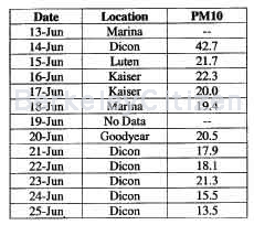
PMI0
The PM10 data was collected using the Personal DataRAM 1000 with a BGI conical inhalable sampler using a foam insert as a size separator. Flow was 2.2 L/min. The 15 minute averages were averaged into an overall 24-hour average, as shown in Table 4. The concentrations reflect the main contribution to PM1O which appears to be regional sources, since there is little difference between the various sites. Except for the anomalously high value on June 14, there is little difference between downtown with its many sources vs. up in the Berkeley hills at the Luten residence with its exposure to air primarily from larger regional air masses.
Table 4. PM10 Mass Concentrations (ug/m3)
None of the data exceeded state or federal air quality standards. The real-time profiles do show some changes over the 24-hour periods monitored, but there is no diurnal pattern to be discerned. This lack of a daily pattern reinforces the conclusion about regional contribution as opposed to localized sources. These time-resolved plots are contained in the appendix. The daily averages are plotted in Figure 7.
Figure 7. PM 10 Mass Concentrations (ug/m3)
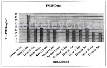
PM2.5
PM2.5 was collected using a MIE DataRAM 2000 equipped with a URG PM2.5 cyclone inlet. The flow from this instrument was manifolded with other instruments to insure the required 10 L/mm. For PM2.5 separation.
The data was collected on 15 minute intervals over 24-hours, with these values averaged into a daily average. Table 5 contains the results from this sampling.
Table 5. PM2.5 Mass Concentration (ug/m3)
Figure 8 contains a plot of the daily averages, and the appendix contains the plots from the daily real-time data acquisition. The time resolved plots show more structure than the PM10 data, which is indicative of localized sources such as industrial and vehicular activities. There are hints of diurnal patterns, with slightly higher trends over several hours, and there are many individual high concentration peaks of up to four to five times the average. These individual peaks are difficult to correlate with specific activities giver the survey nature of the monitoring.
Figure 8. PM2.5 Mass Concentration (ug/m3)
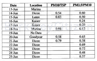
Ratio of PM Concentrations
The magnitude of the average and the ratio between the various size fractions both provide information about potential sources of the particulate matter. As discussed above, the PM10 data suggest a regional contribution while the PM2.5 is much more variable, suggesting localized sources. Besides the magnitude of the concentrations, the ratio of the various size fractions provides other interpretive clues. The ratio of PM10 to TSP for the June 14 and June 20 sampling days of 0.54 and 0.58 are close to a generally applied ratio of 0.55 for urban particulates. Indeed, these two locations are typical of urban atmospheres. The ratio of PM2.5 to PM10 is less straightforward, since PM2.5 can originate from many physico-chemical mechanisms, and the vicinity of combustion or other industrial sources may contribute.
Table 6. Ratio of PM Concentrations
The ratios found at the Marina of 0.98 and 0. 12 suggest that PM10 dominates the regional atmosphere, including the influence of clean ocean air. The ratios of 0.24 and 0.20 at Kaiser reflect the same influence, notwithstanding the presence of 1-80 sources. The higher ratios away from the water reflect the decreasing influence of the clean ocean air and the dominance of the PM10 air masses.
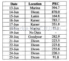
Diesel
Diesel exhaust was measured using particulate elemental carbon (PEC) or black carbon, as the surrogate for diesel exhaust. PEC has been shown to be primarily derived from diesel exhaust with little contribution from automotive sources. However, diesel exhaust also contains from 30 to 60% other materials, including unburned fuel, lubrication oil, and other non-elemental carbon combustion byproducts. Therefore, for a more realistic correlation with diesel exhaust emissions, the PEC concentration should be divided by 0.5, which is mid-way among the literature values for the various constituents of exhaust.
The PEC measurements were made with the Andersen Instrument AE- 16 aethalometer, which uses the light absorption by the collected aerosol at 880 nm to determine the black carbon concentration. Sampling was done on a 15-minute basis, with the daily average computed from these values. Table 7 contains the daily average concentration in ng/m3. Note: divide by 1000 to get the other common unit of ug/m3. Figure 9 shows a plot of these daily averages. The time-resolved data are contained in the appendix, and show consistent patterns of morning and afternoon traffic peaks.
Table 7. Daily PEC Concentrations (ug/m3)
The concentrations measured on a daily average basis reflect the other parameters on a day to day basis. The data from June 14 shows the highest concentrations. The difference between the Friday, June 16 data at Kaiser right adjacent to 1-80 and the Saturday, June 17 is more than a factor of two, indicating the difference in traffic between those days. In addition, the peak values reached over 2.5 ug/m3 for short periods on Friday, June 16, while the highest levels on Saturday, June 17 were less than 0.9 ug/m3. The effect of close proximity to the 1-80 corridor is clear from the high values measured directly adjacent to the highway.
The continuing dilution when going from the highway area to the Berkeley hills is represented by the trend of the Kaiser data, the Dicon data (on days other than the heavily polluted day, June 14), the Goodyear data, followed by the Luten data. The data from the Luten site shows the effect of dilution from the many emission sources upwind in the lower elevation parts of the city. An approximate factor of two dilution is suggested between what would be a general average in town and the more isolated Berkeley hills.
The Marina data from June 13 reflects the same shift towards the higher concentration data due to stagnant, high pollutant conditions as found on June 14 at Dicon. The second Marina day showed an average of 73.1 ng/m3, which is representative of background conditions coming off the clean ocean air.
Figure 9. Particulate Elemental Carbon Concentrations (ng/m3)
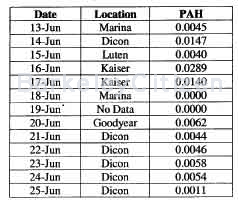
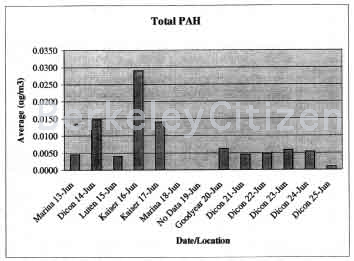
PAH
The total PAH concentrations were measured with the Ecochem PAS 2000, which draws air past a 6 electron volt lamp that photoionizes the PAH molecules adsorbed on the surface of the aerosol. The response for the different PAH compound varies, so no direct correlation with individual species is possible.
The value of this data is in correlating the particulate elemental carbon with the PAH data. In some cases, the ratio between these two parameters can assist in distinguishing the source of a combustion aerosol product. For example, fresh diesel responds more directly to the UV light of the PAS than aged aerosol. Similarly, wood smoke has a different response than diesel exhaust. The relative absorption by fresh exhaust versus aged exhaust can be seen in the relative differences for both PEC and PAH between the Kaiser data on June 16 and the Dicon data on June 14. The ratio between these two days is significantly higher for PAH than for PEC, suggesting that the fresh exhaust provided a higher relative response compared to the more aged exhaust that was sampled at Dicon. The PEC is not affected by photochemical activity, while PAH is quite photochemically active.
The data for the PAH sensor is contained in Table 8 and Figure 10.
Table 8. Total PAH Concentration (ug/m3)
The PAH data correlated well visually with the PEC data, suggesting that the majority of the response was from diesel exhaust. As with other data, the difference between days correlated well with the general trend. The Kaiser data adjacent to 1-80 showed a significantly higher concentration level than areas away from that source. The difference between the Friday Kaiser data and the Saturday Kaiser data was a factor of two, similar to the PEC data difference.
Figure 10. PAH Concentrations (ug/m3)
The PAH data from June 14 at Dicon is nearly a factor of two lower than the Kaiser data on June 16, which is in contrast to all the other data. Combined with the PEC data for those two days, it suggests that the majority of the pollutant load on June 14 was from regional stagnation of vehicular emissions.
Since the PAS does not provide any chemical speciation information, it cannot be used to derive any conclusions about specific exposure or the risk associated with the toxic PAH compounds.
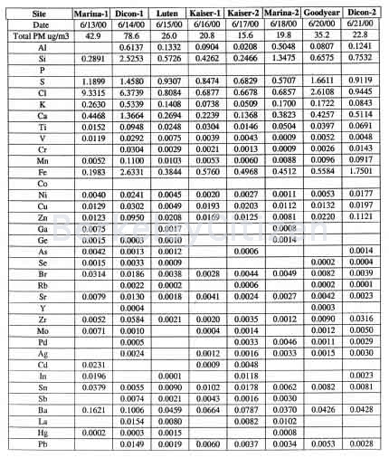
Metals
Metallic elements in aerosols were collected on Teflon filters and analyzed by x-ray fluorescence. The metals concentration are contained in Table 9.
Table 9. Metal Element Mass Concentration (ug/m3)
The metals concentration do not show anything remarkable. The same daily trends as with previous parameters were confirmed with this data set. One of the most toxic metals is chromium VI, which although not directly measured in this method, is often estimated by taking 8% of the total chromium concentration. The highest concentration of all the days was 0.03 ug/m3, 8% of gives 0.002 ug/m3, which is below annual CARB data from San Francisco of 0.0031 ug/m3.Volatile Organic Compounds
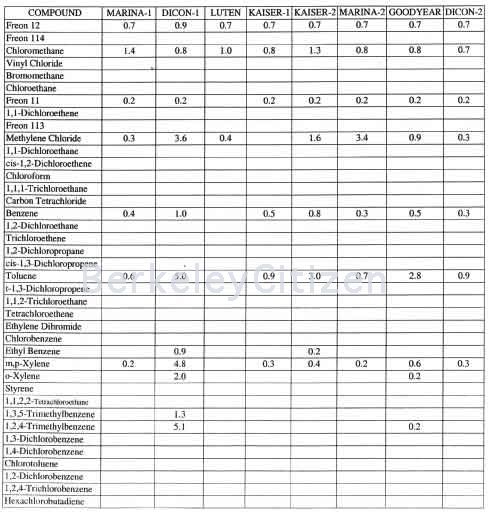
VOCs were collected using Summa canisters to draw sample in through a critical orefice over a 24 hour period. The samples were analyzed using cryofocus preconcentration gas chromatography/mass spectrometery.
Table 10. Volatile Organic Compounds
Continue to: West Berkeley Air Monitoring Part 2

All Rights Reserved